
Since becoming the metropolitan planning organization for the Bellingham Urbanized Area in 1982, WCOG has been engaged in a robust program of transportation planning to satisfy the numerous planning requirements to keep the region eligible for federal transportation assistance. Following its designation in 1990 as the regional transportation planning organization for Whatcom County under Washington’s GMA, WCOG merged its MPO and RTPO responsibilities into a unified metropolitan/regional transportation planning program. Additionally, WCOG provides technical assistance and support to its member jurisdictions and assists its various partners, including WSDOT, WTA and others.
Metropolitan and regional transportation planning
As an MPO, WCOG is responsible for carrying out a comprehensive, cooperative and continuing planning process for the Bellingham Urbanized Area. As part of that “3C” process it subsequently included its state-mandated RTPO planning requirements. Among the principle activities and products generated by this process are:
- Development of a long-range metropolitan transportation plan, which must be updated every five years. The update to Whatcom Mobility 2040 will begin in 2020, with adoption by June 2022.
- Preparation of an annual (or biennial) Unified Planning Work Program (UPWP), the focus of which is derived from the adopted metropolitan long-range transportation plan (Whatcom Mobility 2040) as well as the planning emphasis areas specified in federal regulations and in the Revised Code of Washington.
- In cooperation with WCOG’s members and WSDOT, preparation of the Regional Transportation Improvement Program. The TIP provides a comprehensive six-year listing of transportation improvements within the county that are included on the regional transportation network as defined by Whatcom Mobility 2040. It also includes any other projects utilizing federal transportation funds, regardless of their location.
- As an RTPO, WCOG must certify that the “transportation elements” of the comprehensive plans of Whatcom County and the region’s seven cities are consistent with the provisions of the GMA and the current adopted regional transportation plan.
These activities and others are ongoing as part of WCOG’s responsibility to advance the region’s transportation goals and to support state and national transportation objectives.
Performance-based planning and programming
Federally required measures and targets:
With the passage in 2012 of the federal transportation act called Moving Ahead for Progress in the 21st Century (MAP-21), MPOs must establish and utilize a performance-based approach to transportation planning and decision-making in support of the national planning factors. MAP-21 also established requirements for states and MPOs to adopt specific performance measures and targets in the areas of safety, infrastructure condition, system performance and environmental sustainability. (All of these MAP-21 requirements were carried forward into its successor, Fixing America’s Surface Transportation, known as the “FAST Act.”)
Safety: Per the federal rules on safety performance measures, states shall measure transportation safety performance using five USDOT-defined metrics –permutations of crash statistics on all public roads reported by severity (fatal, serious injury) and expressed as five-year rolling averages of counts and rates-per-vehicle-miles-traveled. States and MPOs must have established targets for improvement in terms of the five measures. Under the rules, MPOs may choose to establish targets either by 1) agreeing to plan and program projects so that they contribute toward the accomplishment of the state’s adopted target or 2) by developing and tracking their own targets.
Information on WSDOT’s safety metrics and targets can be found here.
WCOG, like all MPOs in Washington, chose to align with the state’s target and in January, 2018 passed the following motion:
In accordance with USDOT’s safety performance rules, the Whatcom Council of Governments Transportation Policy Board adopts Washington’s Highway Safety Improvement Program (HSIP) target and thus agrees to plan and program projects so that they contribute toward the accomplishment of that HSIP target (Target Zero). – Passed by the Whatcom Transportation Policy Board, January 17, 2018.
System Performance: Per the federal rules on system performance, states and MPOs are required to adopt metrics and targets to track progress on congestion reduction, system reliability, freight movement & economic vitality, and environmental sustainability. The U.S. Federal Highway Administration (FHWA) has developed data sets and standardized measures that states can elect to use. WSDOT has elected to use these.
Information on WSDOT’s application of federal system-performance metrics and application to MPOs can be found here.
In December, 2018, the Whatcom Transportation Policy board passed Resolution 2018-12-01, resolving to:
“…plan and program projects in the Whatcom metropolitan planning area so that they contribute toward the accomplishment of WSDOT statewide performance targets for condition of pavements on the Interstate System and the rest of the National Highway System (excluding Interstates), condition of bridges on the National Highway System, travel time reliability on the National Highway System, and freight movements on the Interstate System.”
Because the urbanized areas in the Whatcom MPO’s planning area do not have populations greater than 200,000, only two of the five federally defined measures currently apply to the Whatcom region – Level of Travel Time Reliability (LOTTR) and Interstate Truck Travel Time Reliability (TTTR) (both described in the above-linked WSDOT document).
WCOG regional corridors:
As part of its efforts to adopt performance-based planning practices, WCOG has identified “regional corridors” that serve as the principal connection between two or more communities in Whatcom County. For each of these corridors a generalized geography was established that accounts for all modes and the system components that facilitate mobility along the corridor (roads, transit routes, trails, etc.). Identification of regional corridors is intended to provide a framework to support coordination between jurisdictions and agencies with operational responsibilities on each corridor (Whatcom County, WTA, WSDOT, etc.). When performance measures are applied to these corridors, WCOG and its partners will be able to track progress toward meeting established operational goals and more clearly identify system needs and the investments necessary to meet them.
Figure 7 below illustrates the eight regional corridors for which WCOG will be developing performance measures and then testing them as a basis for the establishment of an ongoing, corridor-focused planning process with the involved facility owners, operators and users.
Figure 7: Regional Corridors for Performance Measurements
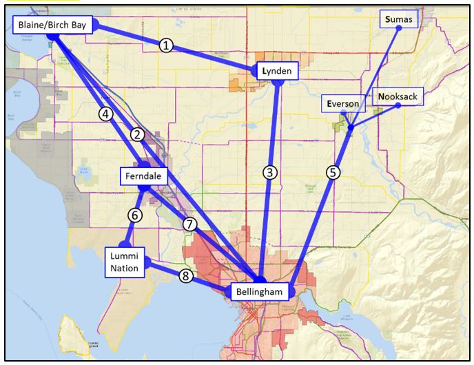
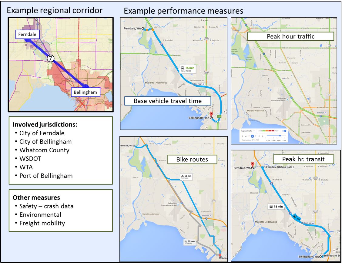
Figure 8 below takes one example corridor (Bellingham-Ferndale) and illustrates a possible application of performance measures. Corridor measures are intended to assess the availability and effectiveness of all modes and support comparison over time so that performance targets can be set and strategies developed to achieve them. Figure 8 also lists the jurisdictions and transportation agencies with responsibilities on this corridor, as well as additional performance measures in support of the Whatcom regional transportation goals.
Figure 8: Example Regional Corridor and Associated Performance Measures
In 2017 and 2018, WCOG will continue working with the region’s jurisdictions and transportation agencies to develop the regional corridor performance measurement framework and use it to form strategies for best serving inter-jurisdictional travel and goods movement across all modes.
Regional coordination of level of service (LOS) standards:
Level of service is a broad term used to describe a measurement of how well a transportation facility (usually a road) or service (like a bus route) is performing. It is important, then, to acknowledge this context before discussing how LOS does and does not fit into WCOG’s planning strategy.
There are various reasons that LOS measures are adopted and applied. In Washington, LOS is defined as “an established minimum capacity for both transit and regional arterials,” and cities and counties subject to GMA are required to establish minimum LOS standards. If, as a result of a jurisdiction’s land-use and transportation analyses, it is determined that development will generate enough vehicle trips to cause arterial roads or transit systems to fall below the adopted LOS minimums, that jurisdiction must then explain how it will pay for additional road capacity or transportation facility improvements, and/or what changes will be made to its land-use plan, to maintain the adopted LOS. Under GMA, this policy of requiring jurisdictions to keep their adopted level of transportation capacity in running balance with vehicle demand is called concurrency, and LOS standards are used to monitor compliance with this requirement.
When applied to road segments, corridors or intersections, LOS measures have typically been based on traffic volume, vehicle travel time, or a combination of variables such as distance traveled, road conditions or safety hazards. Measures such as comparing observed vehicle travel times to a free-flow condition, or comparing observed vehicle counts (volume) to the road’s designed vehicle capacity, are usually batched and associated with a corresponding range of letter grades from “A” – indicating free-flowing vehicle traffic – to “F,” when traffic is at a standstill. In Whatcom County, most (although not all) jurisdictions use an A-F LOS measure based on the volume of vehicles on a road segment compared to its designed vehicle capacity during the afternoon (p.m.) peak hour of traffic.
Example: |
| Whatcom County has adopted an LOS standard of C. If a road segment in the county has a designed capacity of 400 vehicles/hour, but during the p.m. peak hour (e.g., 4:00 to 5:00 p.m.) only 350 vehicles are able to move through it, that segment is operating at LOS D (350/400 = 0.875), which is below the adopted standard. |
LOS Designation Volume/capacity range
A 0 – 0.59
B 0.60 – 0.69
C 0.70 – 0.79
D 0.80 – 0.89
E 0.90 – 0.99
F >1.00
Another reason that jurisdictions adopt LOS standards is to assess impact fees: mandatory payments from land developers to jurisdictions to offset the cost of transportation improvements necessitated by their projects. The use of impact fees is one of the principal means by which jurisdictions fund compliance with GMA’s concurrency requirement. Unlike a county or city, WCOG does not use LOS to assess concurrency or, for that matter, any type of fee calculation. As an RTPO, state law requires WCOG to 1) review level of service methodologies used in the planning area and promote a consistent regional evaluation of transportation facilities and corridors, and 2) work with cities, counties, WTA, WSDOT and others to develop LOS standards or alternative transportation performance measures. The LOS measurement WCOG applies for the purposes of regional transportation planning encompasses a range of methodologies and applications that are used in various ways to measure performance and inform planning.
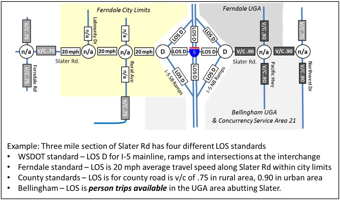
For measures and forecasts of the regional road network generated by its regional travel demand model, WCOG uses the same LOS scale as Whatcom County (shown below the Example box above). While WCOG’s regional LOS measurement sometimes conflicts with that of a particular city, it allows the regional road network to be visualized and assessed in a consistent way across jurisdictional boundaries. This application of LOS also helps communicate the operational effects expected from forecast changes in population as well as funded or planned investments in the regional transportation system. Figure 9 illustrates the difficulty of attempting to use multiple LOS scales in regional transportation planning. Moving across the image from left to right (west to east), Slater Road traverses unincorporated Whatcom County, the City of Ferndale, the I-5 right-of-way (owned by the state), Bellingham’s and Ferndale’s urban growth areas, and unincorporated Whatcom County again.
Figure 9: Challenges in Establishing LOS Measurements
As a general planning principle, WCOG believes consistent transportation metrics are the most helpful in assessing future investment alternatives on facilities owned and operated by multiple jurisdictions, like in the previous example. However, WCOG acknowledges that the jurisdictions’ adoption and use of different LOS methods and standards is not, by itself, an inconsistency with respect to regional planning or the attainment of regional transportation goals. As discussed before, these varying measures and standards are used by jurisdictions for purposes other than planning and are based on locally-preferred metrics (e.g., travel time vs. vehicle volumes), different expectations for system effectiveness (LOS C vs. LOS E), and the amount of funding deemed necessary to maintain or achieve a local LOS standard. However, for regional planning studies led by WCOG or in which WCOG participates (such as a sub-area or corridor study), the use of a consistent LOS methodology will be encouraged.
Least-cost planning:
The Washington Administrative Code requires regional transportation plans prepared by RTPOs to be based on a “least-cost planning methodology appropriate to the region.” Least-cost planning is the process by which a region pursues its transportation goals using the most cost-effective mix of options. Furthermore, the process should:
- Consider both transportation supply strategies (e.g., building or widening roads, adding new transit service, etc.) and demand strategies, such as converting general-purpose lanes into high-occupancy vehicle lanes, transportation demand management programs like Whatcom Smart Trips, charging for parking and similar strategies.
- Consider direct costs like infrastructure, operations, preservation and debt service, and indirect costs such as safety, travel time, air quality, public health and habitat loss.
To meet this administrative requirement, WCOG has done or is doing the following:
- Adopted regional goals that reflect the expectation that the future effectiveness of the regional transportation system should, and will, rely on a mix of options.
- In addition to calling for strategic increases in the supply of transportation infrastructure and services, WCOG has adopted regional transportation-demand strategies, most notably its Whatcom Smart Trips program. Through Smart Trips, WCOG works closely with the jurisdictions and transit providers to support the future effectiveness and attractiveness of transportation modes other than single-occupancy vehicles.
- By adopting regional goals and strategies as a means to both develop and continuously improve performance measures, WCOG’s regional planning activities can include benefit-cost analyses that include indirect cost factors (such as safety, travel time, health, environmental quality), which are essential to a least-cost planning approach.
- As it relates to the desired least-cost planning outcome of “the most cost-effective mix of options,” WCOG has adopted the regional goal of efficiency, effectiveness and system sustainability, which entails:
- Making the best use of available information to identify alternatives
- Evaluating the relative direct and indirect costs and benefits as described above, and
- Using the strategy that the region can afford and that provides the most expected benefit for the least cost.
Longer-range planning in support of public transit
The Whatcom region has two public transit providers: the Lummi Nation’s Lummi Transit system, and the WTA. Lummi Transit service is available to all but primarily serves residents of the reservation. It operates two routes: Route A, which circulates throughout the reservation, and Route B, which provides service between the reservation and the City of Ferndale, where Lummi Transit riders can connect to WTA service at Ferndale Station. If and when requested by the Lummi Nation, WCOG will support and assist Lummi Transit in developing a long-range transit service plan.
In 2017, WTA adopted a new six-year strategic plan. The plan calls for WTA to monitor population growth and employment trends as part of two-year planning cycles, and assume transit demand will follow. If WTA’s growth rate equals the population growth rate of Whatcom County, WTA would need to increase service by approximately 12,000 revenue hours over the life of the six-year plan. Using WTA’s historical growth rate would mean adding approximately 18,000 revenue hours of service; by 2036, these targets would increase to between 35,000 and 55,000 additional hours of service. Of course, exactly where that additional service would be needed is unknown at this time. The allocation of new transit service over Whatcom Mobility 2040’s 23-year planning horizon will be based on the distribution of a significantly larger population – and with different demographic characteristics – than the population in 2017. Future service will also be influenced by land-use decisions, over which WTA has no authority. Given these uncertainties, WTA and WCOG will continue their longstanding collaboration and will pursue the development of a regional, longer-range (i.e., more than six years) planning strategy to optimally provide future transit services. However, to be successful, such a strategy must also include transit-supportive initiatives of local jurisdictions, regional agencies and other institutions, and not merely WTA operational improvements. This includes elements such as roadway design, park-and-ride facilities, bicycle and pedestrian connectivity to transit hubs, information and data sharing, public-private partnerships, and other measures.
Specific longer term transit planning strategies:
The most obvious intersection of WTA’s service goals and WCOG’s regional transportation goals is fostering a multimodal transportation system. Identifying the best strategies to help the region make the highest and best use of all available transportation modes, including transit, depends on knowledge of where the potential ridership is now and will be in the future. Thus, WCOG and WTA will:
- Will ensure that future household travel surveys (undertaken to refresh trip-tables for the regional transportation demand model) include sampling strategies, information fields and temporal parameters to generate useful information for longer-term transit planning.
- Explore geographic information system applications, census data products, and various analytical techniques to improve the quality of demographic data on quarter-mile bands (the approximate maximum walking distance of transit riders) around existing and proposed bus routes.
- Consider strategies for more productive operation of park-and-ride facilities.
- Monitor system conditions that, in the future, may warrant the use of strategies such as congestion-bypass protocols.
- Evaluate demographic trends relative to expected transit use rates, particularly characteristics such as age, income and disability.
- Continue to support inter-regional transit services like the County Connector, and facilitate a continuing dialogue with WSDOT on shared interests in service along state routes.
- Continue to monitor the feasibility of cooperating with regional transit providers in British Columbia to provide an effective cross-border public transit connection.
- Monitor current and potential future activities of private bus companies that serve regional transportation demand and consider how public facilities can complement privately-owned bus services to make the overall system more efficient and successful.
- Monitor the evolution of other transportation services and technologies that are likely to have implications for transit operations and alternatives. Examples include augmenting rural transit service through partnerships with ride-hailing services like Lyft and Uber, and using autonomous transit vehicles when that technology becomes viable.
Freight
In support of the regional goal to provide mobility for freight, WCOG employs several strategies:
- Regional freight system assessment: In 2015, with funding from WSDOT, WCOG undertook a region-wide freight survey, mailing questionnaires to more than 1,000 local companies regarding their current and future freight-transportation needs, their assessment of the current freight system in the region, and recommendations for improvements and other changes. (For findings and analysis, please see the report 2015 WCOG Freight System Assessment.)
- Freight and Goods Transportation System (FGTS): WCOG participates in WSDOT’s data-based FGTS by working with member jurisdictions to provide truck counts on primary roadways that are used to estimate the tonnage of freight moving over them. (More information about the FGTS classification system is available on WSODT’s FGTS webpage.) WCOG uses the FGTS to improve regional awareness of freight flows and trends, and to inform the application of freight criteria in project selection and prioritization.
- Participation in state and federal freight initiatives: In addition to statewide freight planning, WSDOT’s Freight Systems Division undertakes and supports various activities in which WCOG and its member jurisdictions participate. Examples include:
- Stakeholder committee to evaluate an approach to statewide modeling of freight flows.
- Stakeholder review and participation of a process to designate critical urban freight corridors.
WCOG also works closely with the Washington FHWA Division Office to stay aware of federal funding opportunities for freight planning, such as the FAST Freight programs.
- International Mobility and Trade Corridor (IMTC) Program: Analyzing the flow of freight associated with cross-border trade is an important activity of the IMTC Program. IMTC serves as an essential forum through which federal (Canadian and U.S.), state and provincial agencies collaborate on freight planning and freight system operations, which is informed by the involvement of various other IMTC participants, including the B.C. Trucking Association, the Washington Trucking Association, and the Vancouver Airport Authority. In support of these interests, IMTC has conducted a series of cross-border commercial vehicle studies, compiling a time-series on regional cross-border commodity flows, origin-destination data and other trip and conveyance characteristics relevant to cross-border system planning, inspection program strategies, and identification of operational efficiencies.
Human services transportation planning
In 2006, WSDOT directed WCOG and the state’s other regional transportation planning organizations to convene stakeholder groups comprising local human services agencies, schools, transportation providers and others to develop consolidated human services transportation (HST) plans to ensure that the mobility needs of people who do not or cannot drive due to age, income or disability, are being met. This process results in the creation of a prioritized list of HST project proposals within Whatcom County based on the rankings of WCOG’s HST stakeholder group and reviewed by both TTAG and CTAG. Sponsors of project proposals included on the list are then eligible to apply for state and federal public transportation grant funding. (For more information, please see the regional HST plan.)
Regional Intelligent Transportation Systems (ITS) Architecture
Intelligent transportation systems is a broad term that encompasses many different types of technology that are intended to improve mobility. Such improvement may come in the form of shorter travel times, enhanced safety, lower operating costs and other benefits to both operators and users of the transportation system, the latter including drivers, transit users, freight operators and even pedestrians. Generally speaking, a technology is “intelligent” if it has the ability to communicate (with system operators, users of the facility or other components in that system), is dynamic (i.e., it can be adjusted as conditions warrant) and it generates data that can be analyzed to further improve the operation of that specific facility or the broader transportation network. The Whatcom Regional Intelligent Transportation Systems (ITS) Architecture is an inventory of this type of transportation technology that is currently deployed, or deployment of which is planned, in Whatcom County. This Regional ITS Architecture is updated periodically to keep pace with the rapid advancement of transportation technology.
Public Participation Plan
The Federal Highway and Transit administrations have jointly issued an Interim Policy on Public Involvement that supports public involvement at all stages of planning and project development. Federal law requires metropolitan planning organizations to develop, with the public, effective involvement processes tailored to local conditions. The performance standards for these proactive public involvement processes include early and continuous involvement; reasonable public availability of technical and other information; collaborative input on alternatives, evaluation criteria and mitigation needs; open public meetings where matters related to federal-aid highway and transit programs are being considered; and open access to the decision-making process. The State of Washington also requires public participation in the regional transportation planning process. WCOG’s Public Participation Plan provides guidelines for establishing and maintaining robust public involvement in the Whatcom region’s transportation planning process.
Environmental Justice
Environmental justice (EJ) is the practice of identifying and addressing those disproportionately-high adverse effects of transportation programs, policies and activities on minority groups and low-income communities to ensure the equitable distribution of both benefits and burdens. WCOG strives to maintain an awareness of potential EJ issues in its transportation planning process and take the necessary actions to prevent inequitable outcomes. Specific and overlapping strategies include:
- Inclusion of EJ as a specific objective related to the “environmental quality” scoring criterion as part of the evaluation of STBG funding requests.
- Inclusion of the U.S. Environmental Protection Agency’s environmental justice screening and mapping tool (EJSCREEN) on WCOG’s GIS portal.
- WCOG’s human services transportation planning activities (described above) include focused attention on the transportation needs of low-income populations.
The following interactive map series uses data from the EPA’s EJSCREEN to identify potentially vulnerable demographic populations in the Whatcom region.
Figure 10: Environmental Justice in Whatcom County
Safety and environmental quality
Although they are discrete regional transportation goals – as well as being state and federal priorities – safety and environmental quality are also advanced in the Whatcom region through integration with various other planning strategies.
All users of the regional transportation system – from long-haul truckers on Interstate 5 to babies in strollers on sidewalks – have the right to expect that they will be safe using the region’s transportation facilities. As described previously, WCOG has adopted the following strategies to advance this goal.
- In administering the process for awarding the regional appropriation of STBG funds, safety is assigned the highest weighted score under the criteria adopted by the Whatcom Transportation Policy Board. In this way, projects proposed that address locations with a history crashes, and especially fatal or serious-injury crashes, are more likely to be funded than other projects.
- WCOG uses the crash data resources compiled and made available through WSDOT’s Transportation Data, GIS & Modeling Office, particulalry its Crash Data Portal, to monitor and visualize locations in the region that exhibit problematic crash trends. Working with its member jurisdictions, WCOG analyzes these data and supports efforts to identify and fund strategies to address safety issues.
- WCOG will continue to work with WSDOT to formally adopt upcoming standardized FHWA safety performance measures and targets. As suggested in current federal regulations, these will likely consist of region-wide measures of annual fatal and serious injury crashes, assessed on a five-year rolling average.
Together with related state and federal goals, WCOG’s regional transportation goal of environmental quality seeks the following specific outcomes:
- Reduction of greenhouse gas emissions
- Energy conservation
- Protection of the natural environment, including habitat and water quality
- Enhancement of community health, and
- Promotion of consistency between planned land-use and economic development.
To advance these goals, WCOG has adopted the following strategies:
- Environmental quality is second only to safety in the project scoring criteria the Whatcom Transportation Policy Board utilizes in awarding regional STBG funds. Projects that are likely to result in some or all of the aforementioned environmental outcomes tend to rank more highly than funding requests with lesser environmental benefits. WCOG has also added outcomes to the project selection guidance that include addressing environmental justice issues and project implementation strategies that make use of recycled materials.
- WCOG embraces Whatcom County’s adoption of Resolution 2015-038, Committing Whatcom County to Adopt a “Healthy Planning Approach.” As a result, WCOG strives to advance the desired outcomes of health and well-being in its metropolitan and regional transportation planning activities.
Environmental mitigation
Federal regulations require that long-range transportation plans “include a discussion of types of potential environmental mitigation activities and potential areas to carry out these activities, including activities that may have the greatest potential to restore and maintain the environmental functions affected by the plan.” Accordingly, MPOs are required to seek consultation with federal, state and tribal land-management, wildlife and regulatory agencies during the preparation of long-range transportation plans. A list of the agencies that were provided draft versions of this plan for consultation is included in Appendices.